What is the Breeding Bird Survey and what does it do for the birds?
All of us reading this article enjoy birds and want to protect the birds and the places where birds live. One of the most important ways that we both protect birds and our environment is by monitoring bird populations. Unlike nearly all other taxa, birds can be effectively monitored across large geographic areas and over long periods, this is primarily because of the number of competent bird watchers that are willing to volunteer their time and expertise to monitoring birds.
The primary program used to monitor birds in North America is the Breeding Bird Survey (BBS). The BBS started in 1966, at a point in time when the general public was greatly concerned about the health of the environment and birds were the way to monitor the environment. The BBS was one of the contributions provided by Chandler Robbins. Chandler Robbins recently passed away at 98 and was the key figure in the development and use of the BBS. (You can read more about him in this article by the Washington Post.)
The BBS has a rather simple protocol, the US Geological Service at Patuxent Wildlife Research Center randomly choose routes along rural roads. Each route is approximately 25 miles long and there are stops every ½ mile, at each stop a 3 minute survey is conducted and all birds within ¼ mile that are seen or heard are recorded. These routes are conducted from sunrise to about 9:00AM once per year. In Illinois we have 101 routes and in general they are conducted between late May and early July. While we, as a state, have improved the percentage of routes that are completed each year we still often have 8 to 12 routes that are not assigned to a person. This map provide the location of routes and which ones are available.
Why it is important
With the data collected from across North America over the last several decades, statisticians at Patuxent Wildlife Research Center use complex statistician approaches to model how the population of birds are changing. These population trend data are one of the key pieces of data used to determine conservation priorities at various organizations. For example, the US Fish and Wildlife Service use these data to determine priority species. Here in Illinois the Illinois Department of Natural Resources uses these data to help determine which species should be considered in greatest needed of conservation. Partners in Flight has recently produced a very interesting report, Species of Continental Concern, which primarily uses the BBS data.
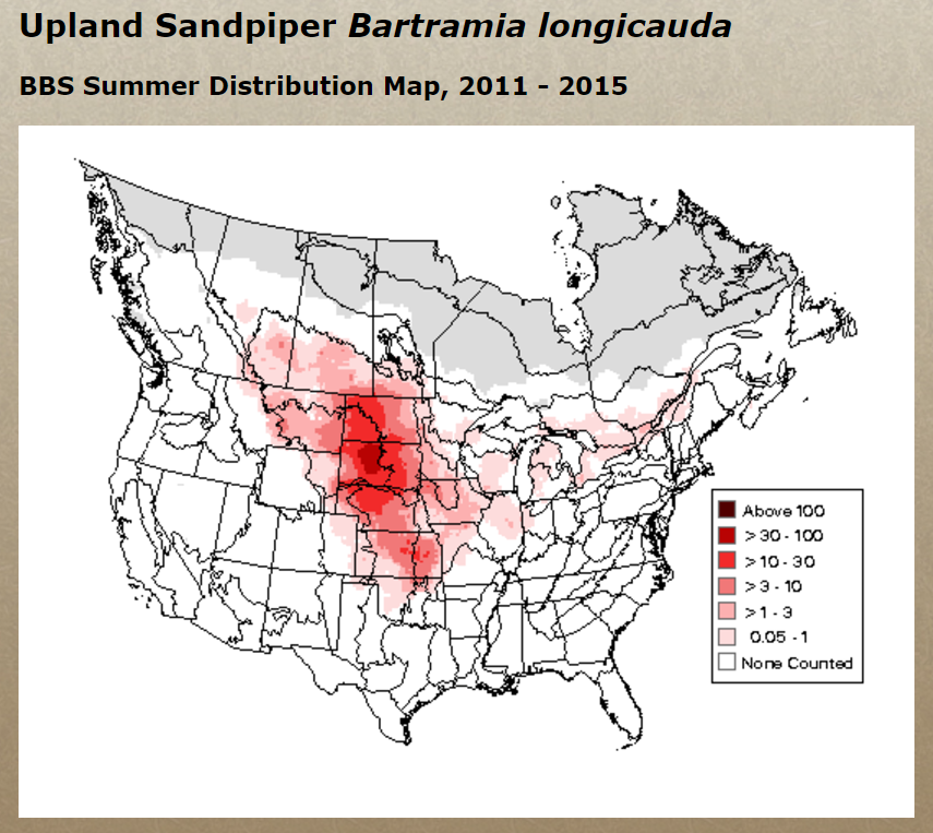
The BBS data not only can be used to inform us about which species is increasing or decreasing, but the data provides the distribution of species. You can view Relative Abundance Maps for each species on the Patuxent Wildlife Research Center Web site.
With the distribution data we can further refine conservation priorities. For example, Illinois is an important area for Dickcissel and Henslow’s Sparrow because we are in the core area of their distribution and a relatively large percentage of their population is in our state. Therefore when determining how to use limited conservation resources we can have additional data to determine where the funds should be used.
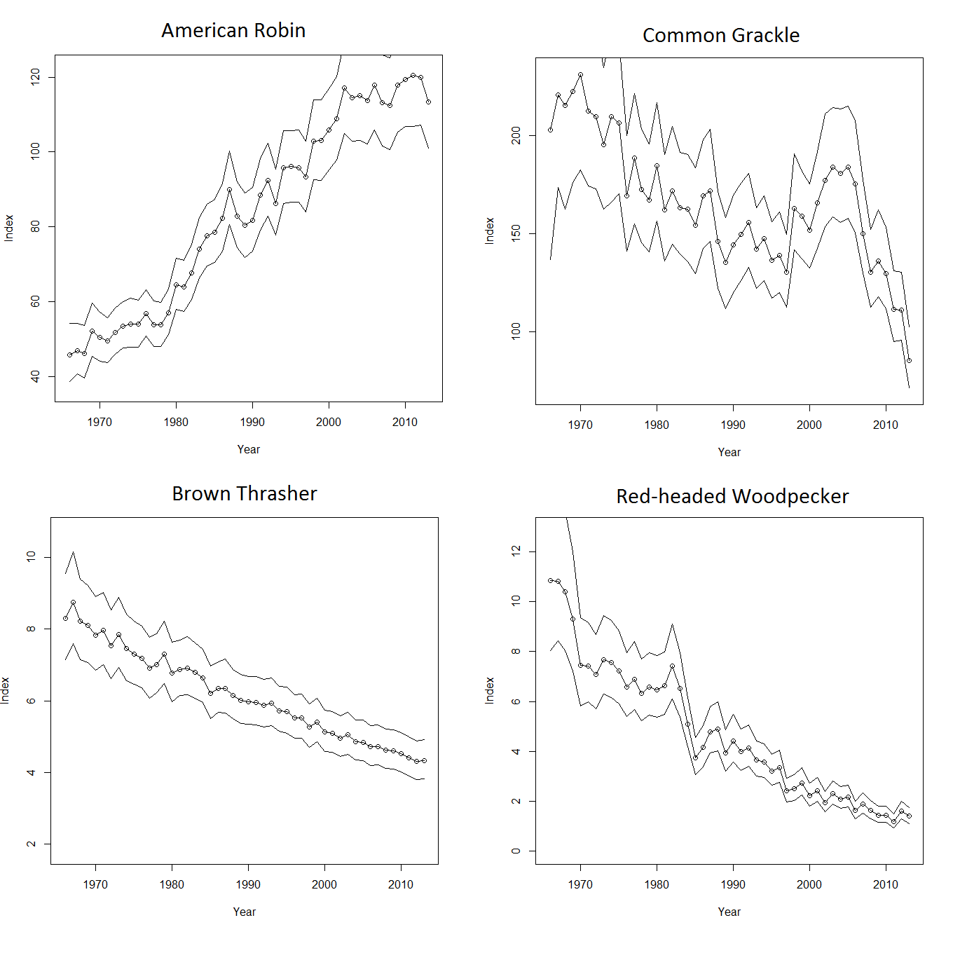
Finally, the BBS can provide the “large scale” view of how bird populations are faring. We all have our favorite areas to go bird watching, and these areas may or may not be representative of the greater population of a given species. In addition, there is a natural tendency for birdwatchers to be more interested in the rarer species. To this end many of us have noticed an increase in Henslow’s Sparrows over the last couple decades and the BBS survey also shows this increase. However, common species that are declining, often are not noticed by the casual observer. For example, if you look out your window right now you might see both American Robins and Common Grackles, both common species in the state, however their population trends are completely different. Where American Robins are exhibiting a steady increase in population, Common Grackles have been declining. Many people have remarked to me about the decline in Red-headed Woodpeckers and sadly the BBS also shows the same decline, however again species that are still relatively common such as Brown Thrashers are showing an alarming decline. The “take home” is that the BBS provides the data to accurately model the population of bird species and with these data we (the conservation community) can hopefully determine why the species is declining and then striving to either reduce or hopefully reverse the decline.
Involvement
I (Mike Ward) am the BBS coordinator for the state of Illinois and therefore one of my responsibilities is to find competent volunteers that can identify the breeding birds of Illinois by sight and sound. Luckily we have many great volunteers in Illinois, but we could use more. It is likely too late to get people signed up for the 2017 breeding season but we will need more people in 2018. Given my career, I work with BBS data often and I often get firsthand experience regarding how important these data are to the conservation planning process. For a different perspective of the BBS I asked a volunteer to provide their impression regarding the data collection process and Ray Boehmer, an IOS member from Urbana, was gracious enough to provide the following:
“I have been doing Breeding Bird Survey (BBS) routes for eight years, starting with one, adding another a couple years later, and then adding a third route this year. Birding is normally a relaxing, low-intensity activity for me, but doing a BBS “kicks it up a notch.” At each of the 50 stops, I have to be alert and on my toes to record every bird seen or heard. It reminds me that I am taking part in the scientific aspects of birding. I have to be as objective and accurate as possible. I really like that about participating in the BBS program.
The starting points for my routes range from 30 minutes to a little more than an hour from my house. So having to get up early is an understatement. But I have always been an early riser, so a 3 AM alarm is not too bad.
My routes mostly go through agricultural areas, with a surprising number of wooded creeks crisscrossing, providing some fairly “birdy” stops. In one 3-minute count, I managed to record 35 individuals representing 15 species. That was intense! Then quickly on to the next stop.
The people organizing, supporting, and promoting the BBS program, at both state and federal levels, are well qualified and easily accessible, making the effort on my part about as easy and smooth as I could possibly want. Recording and submitting the results are easy and user-friendly. I plan to continue participating in the BBS program as long as I can while my vision and hearing remain sharp.”
If you are interested in conducting a BBS route please contact Mike Ward.